Monday, September 30, 2013
Tuesday, September 24, 2013
San Jose Rock and Roll Half Marathon

"Want you to "race" a half marathon. Warm up for fifteen minutes and then run 13 miles at just under half marathon race effort, focusing on keeping it steady start to finish. Better to start a little easy and settle in after a couple miles than busting out of the gate and slowing over the run."
Trying to find a flat half marathon course in Nevada City was a losing proposition, and running along the Bay Trail is getting predictable and boring. So, on a colleague's suggestion, I signed up for the San Jose Rock and Roll Half Marathon, to be held on October 6th. I had no plans to race a half this year, but I am curious to see where my fitness puts me in relation to my previous half marathons. It is a really racy distance. Just long enough to force a pacing plan, but short enough to go hard for the duration. This is one huge benefit to having a coach. He gets me out of my box frequently!
Tuesday, September 17, 2013
Training Reset Week: Pacific Northwest Roadtrip

Hiking up Hurricane Hill Trail out of the Elwha River Ranger Station, I broke the treeline about 4000' above the trail head. The trail cut switchbacks into the steep meadow, and marmot dens dotted the grassland; big, gaping holes in the earth, bringing to mind the Rodents Of Unusual Size (R.O.U.S.) from The Princess Bride.
I kept a sharp lookout for flame spurts and lightning sand, just to be on the safe side. The climb averaged a 17.5% grade over the first 6 miles, and I had 2.5 miles to go before cresting the hill. I moved steadily up the meadow, gaining a ridge and traversing towards the summit, pausing occasionally to snap a picture as more of the epic horizon came into view.
The temperature was perfect and the dramatic skies above Olympic National Park were dotted with summer thunderstorms.
Amidst a week-long road trip around the Olympic Peninsula in Washington, we were camping on the Elwha River. Twirly was driving up to the summit of my run to provide me an aid station before I ran back down into the valley via a more gradual trail. We were not travelling that day, so I chose to stretch my legs on a long run with some elevation, getting up high enough to see the lay of the land, which is mostly covered with rain forest.
The Elwha River is home to the largest dam removal project in US history. The demolition of Elwha Dam and Glines Canyon Dam (105' and 210' tall, respectively) began in 2011. As of August 2013, the project is on hold due to issues with sediment and water treatment. Our campsite was below Glines Canyon Dam, and we could see King Salmon spawning in places that had not seen salmon in the 100 years since the Elwha Dam was completed in 1913.
The Hurricane Hill Trail approaches the summit from the north side. As I neared the peak I found myself surrounded by people enjoying the view. The peak itself resides 650' above the parking lot, accessible by a 1.5 mile trail from the parking lot. Those at the summit had paid their dues getting there, but I still felt out of place amongst the crowd milling around taking pictures of wildlife.
I refilled my pack with Tailwind at Twirly's aid station, and set out for the longer, but more gradual, descent into the valley via the Wolf Creek Trail.
After hiking for 6 miles up the ridiculously steep Hurricane Hill Trail, it felt good to get consistent leg turnover on the decommissioned road that was the Wolf Creek Trail. Overgrown in some places, especially near the bottom, I kept my ears open for bear or elk. The culverts which used to route the runoff beneath the roadbed were clogged, creating quagmires of mud hidden in knee high grass at each creek crossing. I would be cruising along at a good clip and find myself tromping through mud deep enough to swallow a shoe!
Another run of note in Olympic National Park was an 8 mile out and back along the shores of Lake Crescent along the Spruce Railroad Trail. As the name implies, the trail followed an old railroad bed along the shore of the 600' deep lake, which is the largest within the Olympic National Park's boundaries. From the trail head, Twirly and I set out into an old orchard overgrown with moss. Within a mile, the trail joins the old railroad bed. The original rail line was 36 miles long and carried Spruce timbers to nearby Port Angeles, where the wood was sought after for airplane building in World War II. Unfortunately, the Great War ended just days before the line was completed. The rail line did operate for 35 years before the Park Service turned the 4 miles along the lake into trail.
 A little over one mile from the trail head at Devil Point, the path crosses a portion of the lake called the Punchbowl. I was amazed at the azure color of the water; despite overcast skies, the deep water shone blue. I tried to capture the color in photos, but failed to do the striking sapphire water justice. The trail continues through a forest of Fir, Hemlock and Madrone, flirting with the water's edge and occasionally climbing over rock fall. Old tunnels used by the rail line have since collapsed, making for some interesting side features and trail detours. Relatively flat and smooth, this trail is a must see for any one running in the Park.
On our return trip from the northern reaches of the park, we followed the Pacific Coast, stopping briefly in Portland before continuing through Tillamook and following the Oregon shore to Florence. Hiking the dunes at JM Honeyman State Park made for a great sunset, and we wrapped up the trip staying in the coastal redwoods outside Arcata, California in Patrick's Point State Park.
Overall, the road trip was a good reset week for my training. I got some good variety in and didn't push myself too hard. I feel rejuvenated and ready to tackle another training cycle preparing for North Face 50 by way of a 50k in Stinson Beach in just six weeks.
Onwards, as they say.
I kept a sharp lookout for flame spurts and lightning sand, just to be on the safe side. The climb averaged a 17.5% grade over the first 6 miles, and I had 2.5 miles to go before cresting the hill. I moved steadily up the meadow, gaining a ridge and traversing towards the summit, pausing occasionally to snap a picture as more of the epic horizon came into view.
 |
| Mid-meadow panoramic |
The temperature was perfect and the dramatic skies above Olympic National Park were dotted with summer thunderstorms.
Amidst a week-long road trip around the Olympic Peninsula in Washington, we were camping on the Elwha River. Twirly was driving up to the summit of my run to provide me an aid station before I ran back down into the valley via a more gradual trail. We were not travelling that day, so I chose to stretch my legs on a long run with some elevation, getting up high enough to see the lay of the land, which is mostly covered with rain forest.
 |
| Glines Canyon Dam demolition (source) |
 |
| The Elwha Dam demolition (source) |
 |
| Hurricane Hill is obscured by that knoll |
The Hurricane Hill Trail approaches the summit from the north side. As I neared the peak I found myself surrounded by people enjoying the view. The peak itself resides 650' above the parking lot, accessible by a 1.5 mile trail from the parking lot. Those at the summit had paid their dues getting there, but I still felt out of place amongst the crowd milling around taking pictures of wildlife.
 |
| Look! Deer! |
 |
| Mount Olympus is the far horizon, left center |
I refilled my pack with Tailwind at Twirly's aid station, and set out for the longer, but more gradual, descent into the valley via the Wolf Creek Trail.
 |
| Cool running |
After hiking for 6 miles up the ridiculously steep Hurricane Hill Trail, it felt good to get consistent leg turnover on the decommissioned road that was the Wolf Creek Trail. Overgrown in some places, especially near the bottom, I kept my ears open for bear or elk. The culverts which used to route the runoff beneath the roadbed were clogged, creating quagmires of mud hidden in knee high grass at each creek crossing. I would be cruising along at a good clip and find myself tromping through mud deep enough to swallow a shoe!
 |
| The Spruce Line |
 |
| Lake Crescent |

On our return trip from the northern reaches of the park, we followed the Pacific Coast, stopping briefly in Portland before continuing through Tillamook and following the Oregon shore to Florence. Hiking the dunes at JM Honeyman State Park made for a great sunset, and we wrapped up the trip staying in the coastal redwoods outside Arcata, California in Patrick's Point State Park.
Overall, the road trip was a good reset week for my training. I got some good variety in and didn't push myself too hard. I feel rejuvenated and ready to tackle another training cycle preparing for North Face 50 by way of a 50k in Stinson Beach in just six weeks.
Onwards, as they say.
Wednesday, September 11, 2013
Pine to Palm Pacing and Stinson Beach 50K
Training for endurance running can be a fickle mistress. Setting aside the time requirements, the body must struggle to repair itself amidst repeated sessions of damage which increase in intensity over time. Running the fine line between fitness and injury is more art than exercise. In my short running career, I have been sidelined a few times, and I try to learn more about my body and its limitations each time.
It is sad for me to say, but David tore a muscle in his thigh, and has dropped out of the Pine to Palm 100 mile with barely a week to go. My pacing and crewing duties alleviated, I turn my focus to the Stinson Beach 50K in October. Just six weeks before North Face, it will be a good tune-up for the hilly 50 miler. I'm less than stoked about the multiple loop course, but it includes the Steep Ravine climb, the Matt Davis Trail and the Heather Cutoff switchbacks from the Tamalpa Headlands 50K. I love these trails, but running a course twice isn't on my list of favorite things. I'll have to make it interesting by setting a goal to negative split the loops.
David, heartbroken, is considering the Bear 100 in Utah as a replacement race, but with only two weeks to heal, I think his 100 mile goals will have to wait until next year. Get better buddy!
Monday, September 9, 2013
Race Report: 2013 Tamalpa Headlands 50K
 |
| The Tamalpa Headlands 50K Start/Finish line |
My training coming into the race was somewhat lackluster. A pulled groin in May meant that my base building phase was non-existent, and a shameful pacing performance at altitude had not bolstered my confidence. The final month before the race brought some reassurance as I built my volume up to a reasonable level and had a few solid tempo and hill workouts. I took it very easy race week, and felt good at the starting line.
I was joined by Torrey, who had gotten into the race off the wait list only ten days prior. His training consisted of regular Cross Fit workouts, but little distance running. I hoped his lack of fitness would translate into the two of us running together for the bulk of the race, but that just wasn't in the cards.
Without much fanfare, the race started promptly at 8am. The pack jogged across the meadow and turned towards the sea as the course followed Muir Woods Road for a brief leg, and then we all funneled onto the single track of the Redwood Creek Trail. Torrey hung back a few runners, and I had a runner behind me that was breathing like a race horse. "A little early to be laboring like that!" I thought to myself, repeating my mantra for the day: "run within yourself".
We quickly covered the first mile and a half to Muir Beach and began to climb the Coastal Trail towards Pirates Cove. Torrey showed his Cross Fit strength and steadily dropped me on the climb. I let him go.
I was inspired by Lucho and Tawnee, in the most recent Endurance Planet podcast, to ignore the meta data on my Garmin during the race. Only the time of day was displayed; no heart rate, pace, or elevation. If I noticed the vibration of the auto lap alert, I could look to see which mile I had just completed, and how long that mile had taken. I enjoyed the lack of distraction the data so easily becomes, but the end result was that my effort for the race was much higher than any race I have done to date! I'll be examining that more in a future post.
The pace of the conga line along the Pirates Cove single track was comfortable. Once we began the climb out of the cove, I learned that I was surrounded by the 10th-13th place women. I challenged myself to stick with them. They gapped me a little by the crest of the hill, and I kept them in sight on the long, smooth descent to Tennessee Valley, carrying momentum across the valley floor and into the next climb.
The ascent to Wolf Ridge on the Coastal Trail is the steepest section of the course. I had completed the climb in about 23 minutes the week before, and set out to break 20 minutes. I paced myself comfortably ("run within yourself"), and halfway up I realized I had more energy to give, so I began to pass some runners. I caught the small pack of women near the top of the climb, and began looking for opportunities to pass as I bombed down the technical descent to Rodeo Beach. The combination of rocky drops, stairs and logs made good terrain for my "skipping" technique. I encountered Jorge Maravilla leading a group run for San Francisco Running Company on one set of stairs.
"Nice style, you look like you're doing the salsa", Jorge exclaimed.
I could see Torrey in the distance; he'd put about a half mile on me. I carried my speed off the hill and onto Bunker Road, clicking off two sub-9 minute miles (2 of the fastest miles of the day) on the flat road section. The Rodeo Valley aid station was bustling with people, and I did not need anything, so I cruised through without stopping. I caught up to Torrey as I left the station, and we stuck together for the climb up Miwok Trail. We power hiked as I outlined the next few sections of the course for Torrey, and in good time we were running again. Old Springs Trail, one of my favorite descents in the Headlands, took us back into Tennessee Valley, where Twirly was waiting.
Mile 11.5 - 2:10 - 106th place
Upon arriving at the aid station, Twirly gave me my second hydration pack, pre-filled with Tailwind. I had completely emptied the first, about 600 calories in two hours. This was huge for me, as I normally struggle to get that many calories in without my stomach shutting down. So far, I felt great, and my stay at the aid station was brief. Torrey and I set out to climb the Miwok Trail headed for Muir Woods.
Torrey continued to climb much stronger than me, so I told him to get after it, and that I might catch him on the next descent. He steadily moved up the trail, and I repeated my mantra, "run within yourself". The trail levelled out and traversed to Shoreline Highway. Surprisingly, I caught up to Torrey again, and we ran together at a comfortable pace to the highway crossing. Kara Teklinski was pouring water at the aid station and providing encouragement. I drank a cup of water, my first consumption of aid from a station at mile 14.7.
We continued on the Miwok Trail, passing Dias Ridge. My watch read 2 hours and 55 minutes at the 15 mile mark. We were almost exactly on 6 hour pace, which I relayed to Torrey. I took stock, and was happy to realize that I had no significant pains and my energy level was still good. After battling GI issues in almost every ultra I have completed thus far, having my nutrition plan work so well was the highlight of the race for me. Dialing in that aspect leaves me more room to focus on my overall performance.
I dropped Torrey on the descent to Frank Valley and the Redwood Creek Trail, only to have him catch up once I gained the valley floor. We crossed Muir Woods Road, and began to climb Deer Park Trail towards the Dipsea Trail and Cardiac aid station. This section of the course shared a few trails with the Steep Ravine Marathon Torrey and I ran in January, and I was hoping to better my time climbing this segment.
Torrey continued to climb strongly, and dropped me as we hit the Dipsea Trail. I would not see him again until the finish. I continued at a comfortable pace, running what I could and power hiking the rest. The trails were becoming crowded with day hikers from Mill Valley and Stinson Beach, requiring more attention to footing and presenting a challenge to my momentum.
Mile 19.5 - 3:50 - 95th place
As I crested Cardiac Hill, the third place finisher was coming through on his way to the finish. 4 hours into the race, and the leaders were more than 8 miles in front of me! I was falling behind on my second pack of Tailwind; I should have been close to empty, but still had about half of a bladder. So, I ate some aid station fare: a pb&j square, some potato chips and a slice of melon. Then, I was off towards the Pantoll Ranger Station and the Matt Davis Trail.
My stomach began to slosh during this stretch, so I ate a ginger chew and slowed my pace a little. I leap-frogged with a couple of runners on the rolling stretch of Mine Trail that connected the aid station and the Ranger Station. Once I got to the Matt Davis Trail, I was running alone. A couple of hikers said "it's all downhill from here" as I set out for the descent to Stinson Beach. Of course, the next 2.5 miles were rolling, and had a few climbs requiring hiking.
The Matt Davis Trail was one that I had not run before. It had a reputation for being the most picturesque way to get to Stinson Beach, and I was looking forward to the views. Once the trail began its steep descent, however, my focus was on footing and negotiating the hikers, who were getting more dense as I neared the coast. I felt strong on the technical descent, a continuing theme of my race. I attacked the trail at every opportunity, and alerted the hikers with ample time, so that I might keep my speed up. At one particularly congested switch back, I actually had to hurdle a small child!
Mile 24.1 - 4:44 - 88th place
I cruised into the Stinson Beach aid station feeling a bit worn out from the descent, and with only 10K to the finish, I dropped my pack with Twirly and poured the remainder of the Tailwind into a handheld bottle. Torrey had just left the station, and I was surprised to see Chris Jones limping out of the station as I was getting situated.
"What the hell are you doing behind me Chris?" I exclaimed.
"I'm in front of you now!" he said with a grin, hobbling up the road to the Dipsea Trail.
Once I had everything straight, and got a kiss from Twirly, I set out in pursuit of Chris. I knew the climb from the beach through Steep Ravine would be tough, and I figured I could catch Chris in his addled state. I put my head down and hiked as hard as I could, running every flat-ish section. I caught Chris in a couple of miles, and together we trudged up the steps on the ravine floor. It felt good to be in the rain forest shade of the ravine, and despite feeling horrible, Chris was good company and set a decent pace as we picked our way through the throngs of hikers.
We passed the marathon mark, and I allowed myself one glance at my Garmin details to figure out the elevation and elapsed time. 6600' of elevation gain in 5 hours and 36 minutes. Compared to the Steep Ravine Marathon, I'd only lost ten minutes over that distance, which meant I was in better shape than I thought coming off my injury.
At Pantoll, a volunteer once again said "it's all downhill from here!", and I said goodbye to Chris, encouraging him to finish strong. The pain was slowing me down a little, and I loped into the Cardiac aid station looking for a refill of my bottle and enough calories to get me to the finish line. Chris was coming into the station as I left, and I set a goal to get to the finish as fast as I could. I was smelling the barn like never before; the faster I ran the sooner I would be done.
Mile 27.7 - 5:49 - 88th place
Aside from one small but insulting climb, the final 5k was fast. Time seemed to slow down, and I was getting a little bit of tunnel vision when slam! I hit the ground. I bounced back up and resumed running, brushing the dust off. I wasn't hurt, but I needed to focus on my footing and not let my fatigue put me in a precarious spot. The final mile and a half were maddening; a never ending series of switch backs. The finish line was visible, but never really seemed to get any closer. Gradually, the sound of the announcer calling out names and the crowd cheering grew. I felt like I was bonking, I had no energy and my water bottle was nearing empty, but I took advantage of the downhill and gave in to gravity, pulling out a sub 27 minute 5k coming into the finish line.
I was happy with my finish, even though I did not meet my goal of sub-6 hours. I had no acute pain, and my plan had unfolded well. Free pizza and beer amongst friends and a ten minute massage put the icing on the cake. We continued the post race celebration with a trip to Fish. for dinner, something I could get used to!
Overall, the race organization was stellar. The volunteers were effusive in their encouragement and support, and I tried to recognize each and every one of them for being out there, to which they almost always replied in kind. Without the volunteers, there would be no race. What they all seemed to recognize, is that without the runners, there can be no race either. The course contained some of the best trails the Headlands have to offer, and I can easily imagine returning to this race year after year. Even though it is not a PR course, the experience left me feeling satisfied, and I would encourage any ultra runner with the time to check out the Tamalpa Headlands 50K. You won't be disappointed!
For the number junkies, here's the Garmin data:
Without much fanfare, the race started promptly at 8am. The pack jogged across the meadow and turned towards the sea as the course followed Muir Woods Road for a brief leg, and then we all funneled onto the single track of the Redwood Creek Trail. Torrey hung back a few runners, and I had a runner behind me that was breathing like a race horse. "A little early to be laboring like that!" I thought to myself, repeating my mantra for the day: "run within yourself".
We quickly covered the first mile and a half to Muir Beach and began to climb the Coastal Trail towards Pirates Cove. Torrey showed his Cross Fit strength and steadily dropped me on the climb. I let him go.
I was inspired by Lucho and Tawnee, in the most recent Endurance Planet podcast, to ignore the meta data on my Garmin during the race. Only the time of day was displayed; no heart rate, pace, or elevation. If I noticed the vibration of the auto lap alert, I could look to see which mile I had just completed, and how long that mile had taken. I enjoyed the lack of distraction the data so easily becomes, but the end result was that my effort for the race was much higher than any race I have done to date! I'll be examining that more in a future post.
 |
| Entering Pirates Cove |
 |
| Single track conga line |
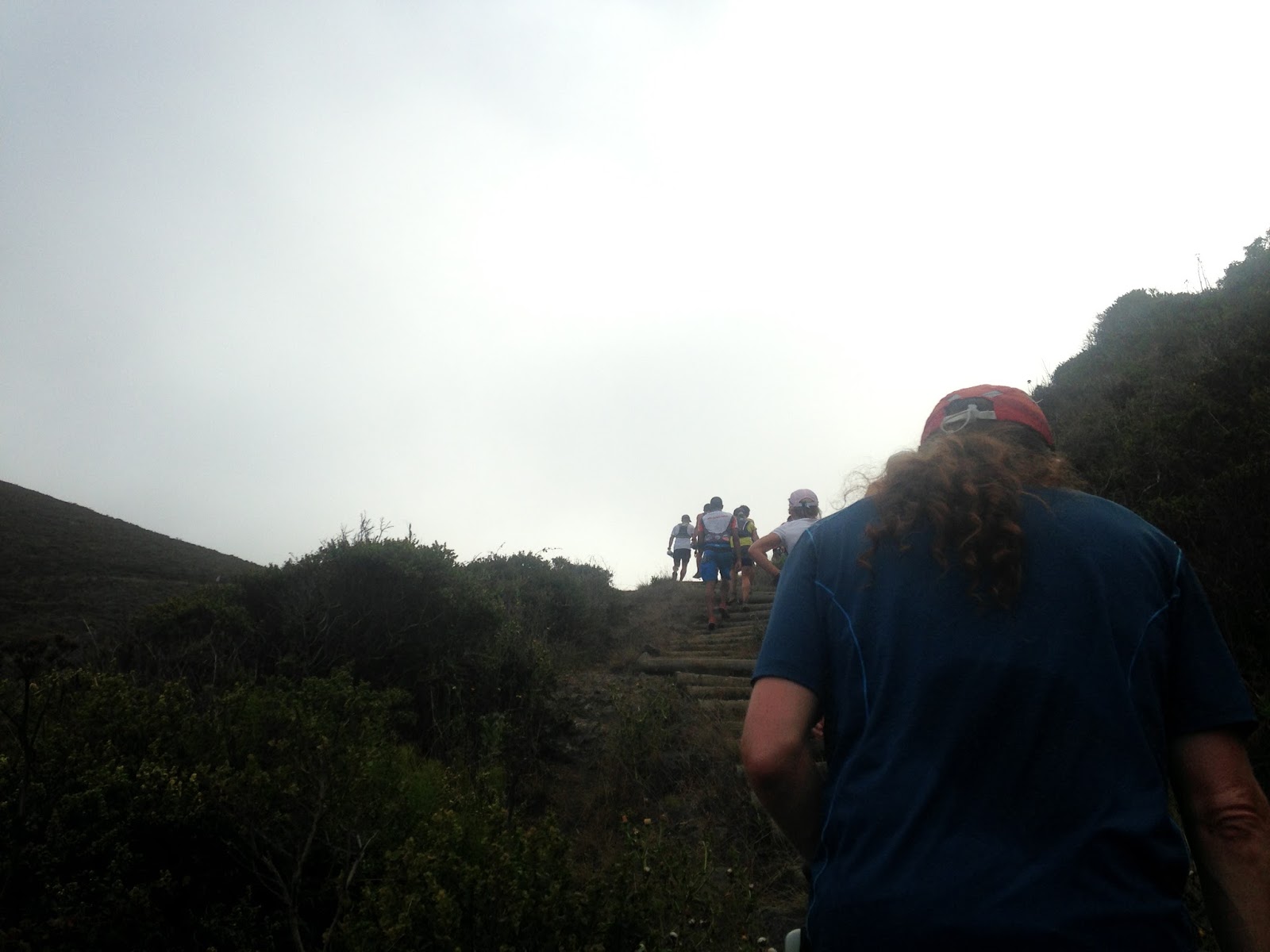
The pace of the conga line along the Pirates Cove single track was comfortable. Once we began the climb out of the cove, I learned that I was surrounded by the 10th-13th place women. I challenged myself to stick with them. They gapped me a little by the crest of the hill, and I kept them in sight on the long, smooth descent to Tennessee Valley, carrying momentum across the valley floor and into the next climb.
 |
| The leaders climb out of Pirates Cove |
 |
| Pirates Cove stairs |
 |
| Wolf Ridge in the fog |
"Nice style, you look like you're doing the salsa", Jorge exclaimed.
I could see Torrey in the distance; he'd put about a half mile on me. I carried my speed off the hill and onto Bunker Road, clicking off two sub-9 minute miles (2 of the fastest miles of the day) on the flat road section. The Rodeo Valley aid station was bustling with people, and I did not need anything, so I cruised through without stopping. I caught up to Torrey as I left the station, and we stuck together for the climb up Miwok Trail. We power hiked as I outlined the next few sections of the course for Torrey, and in good time we were running again. Old Springs Trail, one of my favorite descents in the Headlands, took us back into Tennessee Valley, where Twirly was waiting.
Mile 11.5 - 2:10 - 106th place
Upon arriving at the aid station, Twirly gave me my second hydration pack, pre-filled with Tailwind. I had completely emptied the first, about 600 calories in two hours. This was huge for me, as I normally struggle to get that many calories in without my stomach shutting down. So far, I felt great, and my stay at the aid station was brief. Torrey and I set out to climb the Miwok Trail headed for Muir Woods.
Torrey continued to climb much stronger than me, so I told him to get after it, and that I might catch him on the next descent. He steadily moved up the trail, and I repeated my mantra, "run within yourself". The trail levelled out and traversed to Shoreline Highway. Surprisingly, I caught up to Torrey again, and we ran together at a comfortable pace to the highway crossing. Kara Teklinski was pouring water at the aid station and providing encouragement. I drank a cup of water, my first consumption of aid from a station at mile 14.7.
 |
| The view from Miwok Cut-Off Trail |
I dropped Torrey on the descent to Frank Valley and the Redwood Creek Trail, only to have him catch up once I gained the valley floor. We crossed Muir Woods Road, and began to climb Deer Park Trail towards the Dipsea Trail and Cardiac aid station. This section of the course shared a few trails with the Steep Ravine Marathon Torrey and I ran in January, and I was hoping to better my time climbing this segment.
Torrey continued to climb strongly, and dropped me as we hit the Dipsea Trail. I would not see him again until the finish. I continued at a comfortable pace, running what I could and power hiking the rest. The trails were becoming crowded with day hikers from Mill Valley and Stinson Beach, requiring more attention to footing and presenting a challenge to my momentum.
 |
| Dipsea Trail marker |
As I crested Cardiac Hill, the third place finisher was coming through on his way to the finish. 4 hours into the race, and the leaders were more than 8 miles in front of me! I was falling behind on my second pack of Tailwind; I should have been close to empty, but still had about half of a bladder. So, I ate some aid station fare: a pb&j square, some potato chips and a slice of melon. Then, I was off towards the Pantoll Ranger Station and the Matt Davis Trail.
My stomach began to slosh during this stretch, so I ate a ginger chew and slowed my pace a little. I leap-frogged with a couple of runners on the rolling stretch of Mine Trail that connected the aid station and the Ranger Station. Once I got to the Matt Davis Trail, I was running alone. A couple of hikers said "it's all downhill from here" as I set out for the descent to Stinson Beach. Of course, the next 2.5 miles were rolling, and had a few climbs requiring hiking.
The Matt Davis Trail was one that I had not run before. It had a reputation for being the most picturesque way to get to Stinson Beach, and I was looking forward to the views. Once the trail began its steep descent, however, my focus was on footing and negotiating the hikers, who were getting more dense as I neared the coast. I felt strong on the technical descent, a continuing theme of my race. I attacked the trail at every opportunity, and alerted the hikers with ample time, so that I might keep my speed up. At one particularly congested switch back, I actually had to hurdle a small child!
Mile 24.1 - 4:44 - 88th place
I cruised into the Stinson Beach aid station feeling a bit worn out from the descent, and with only 10K to the finish, I dropped my pack with Twirly and poured the remainder of the Tailwind into a handheld bottle. Torrey had just left the station, and I was surprised to see Chris Jones limping out of the station as I was getting situated.
"What the hell are you doing behind me Chris?" I exclaimed.
"I'm in front of you now!" he said with a grin, hobbling up the road to the Dipsea Trail.
Once I had everything straight, and got a kiss from Twirly, I set out in pursuit of Chris. I knew the climb from the beach through Steep Ravine would be tough, and I figured I could catch Chris in his addled state. I put my head down and hiked as hard as I could, running every flat-ish section. I caught Chris in a couple of miles, and together we trudged up the steps on the ravine floor. It felt good to be in the rain forest shade of the ravine, and despite feeling horrible, Chris was good company and set a decent pace as we picked our way through the throngs of hikers.
We passed the marathon mark, and I allowed myself one glance at my Garmin details to figure out the elevation and elapsed time. 6600' of elevation gain in 5 hours and 36 minutes. Compared to the Steep Ravine Marathon, I'd only lost ten minutes over that distance, which meant I was in better shape than I thought coming off my injury.
At Pantoll, a volunteer once again said "it's all downhill from here!", and I said goodbye to Chris, encouraging him to finish strong. The pain was slowing me down a little, and I loped into the Cardiac aid station looking for a refill of my bottle and enough calories to get me to the finish line. Chris was coming into the station as I left, and I set a goal to get to the finish as fast as I could. I was smelling the barn like never before; the faster I ran the sooner I would be done.
Mile 27.7 - 5:49 - 88th place
Aside from one small but insulting climb, the final 5k was fast. Time seemed to slow down, and I was getting a little bit of tunnel vision when slam! I hit the ground. I bounced back up and resumed running, brushing the dust off. I wasn't hurt, but I needed to focus on my footing and not let my fatigue put me in a precarious spot. The final mile and a half were maddening; a never ending series of switch backs. The finish line was visible, but never really seemed to get any closer. Gradually, the sound of the announcer calling out names and the crowd cheering grew. I felt like I was bonking, I had no energy and my water bottle was nearing empty, but I took advantage of the downhill and gave in to gravity, pulling out a sub 27 minute 5k coming into the finish line.
 |
| Finished: 6:23:07, 86th place, photo courtesy of Brightroom |
I was happy with my finish, even though I did not meet my goal of sub-6 hours. I had no acute pain, and my plan had unfolded well. Free pizza and beer amongst friends and a ten minute massage put the icing on the cake. We continued the post race celebration with a trip to Fish. for dinner, something I could get used to!
 |
| Fish. it's what's for dinner (yes, 32 oz beers) |
For the number junkies, here's the Garmin data:
Subscribe to:
Posts (Atom)